


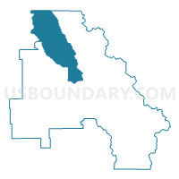
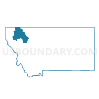
Precinct 21*, Flathead County, Montana
About
Outline

Summary
| Unique Area Identifier | 611971 |
| Name | Precinct 21* |
| County | Flathead County |
| State | Montana |
| Area (square miles) | 583.01 |
| Land Area (square miles) | 579.63 |
| Water Area (square miles) | 3.38 |
| % of Land Area | 99.42 |
| % of Water Area | 0.58 |
| Latitude of the Internal Point | 48.72488250 |
| Longtitude of the Internal Point | -114.37044120 |
Maps

Graphs
Select a template below for downloading or customizing gragh for Precinct 21*, Flathead County, Montana


Neighbors
Neighoring Voting District (by Name) Neighboring Voting District on the Map
- Precinct 14, Flathead County, MT
- Precinct 16, Flathead County, MT
- Precinct 17, Flathead County, MT
- Precinct 21, Flathead County, MT
- Precinct 35, Flathead County, MT
- Precinct 39, Flathead County, MT
- Precinct 48, Flathead County, MT
- Precinct 49, Flathead County, MT
- Precinct 8, Flathead County, MT
Top 10 Neighboring County Subdivision (by Population) Neighboring County Subdivision on the Map
- Whitefish CCD, Flathead County, MT (12,996)
- Columbia Falls CCD, Flathead County, MT (8,895)
- Eureka CCD, Lincoln County, MT (6,221)
- Bad Rock-Columbia Heights CCD, Flathead County, MT (5,200)
- South Fork CCD, Flathead County, MT (2,495)
- Glacier National Park CCD, Flathead County, MT (31)
Top 10 Neighboring Place (by Population) Neighboring Place on the Map
- Columbia Falls city, MT (4,688)
- Hungry Horse CDP, MT (826)
- Coram CDP, MT (539)
- Martin City CDP, MT (500)
Top 10 Neighboring Elementary School District (by Population) Neighboring Elementary School District on the Map
- Columbia Falls Elementary School District, MT (14,331)
- Whitefish Elementary School District, MT (12,979)
- Eureka Elementary School District, MT (4,902)
- Olney-Bissell Elementary School District, MT (1,158)
- Fortine Elementary School District, MT (770)
- Trego Elementary School District, MT (588)
- West Glacier Elementary School District, MT (486)
Top 10 Neighboring Secondary School District (by Population) Neighboring Secondary School District on the Map
- Columbia Falls High School District, MT (14,817)
- Whitefish High School District, MT (13,656)
- Lincoln County High School District, MT (6,260)
Top 10 Neighboring State Legislative District Lower Chamber (by Population) Neighboring State Legislative District Lower Chamber on the Map
- State House District 6, MT (13,427)
- State House District 5, MT (11,824)
- State House District 2, MT (10,711)
- State House District 3, MT (10,443)
- State House District 4, MT (10,360)
Top 10 Neighboring State Legislative District Upper Chamber (by Population) Neighboring State Legislative District Upper Chamber on the Map
- State Senate District 3, MT (25,251)
- State Senate District 2, MT (20,803)
- State Senate District 1, MT (19,687)
Top 10 Neighboring 111th Congressional District (by Population) Neighboring 111th Congressional District on the Map
Top 10 Neighboring Census Tract (by Population) Neighboring Census Tract on the Map
- Census Tract 4, Lincoln County, MT (6,221)
- Census Tract 4.01, Flathead County, MT (5,300)
- Census Tract 2.01, Flathead County, MT (4,543)
- Census Tract 3, Flathead County, MT (4,369)
- Census Tract 2.03, Flathead County, MT (4,261)
- Census Tract 1, Flathead County, MT (3,255)
- Census Tract 2.02, Flathead County, MT (2,736)
Top 10 Neighboring 5-Digit ZIP Code Tabulation Area (by Population) Neighboring 5-Digit ZIP Code Tabulation Area on the Map
- 59912, MT (13,499)
- 59937, MT (12,588)
- 59917, MT (4,225)
- 59919, MT (839)
- 59913, MT (675)
- 59918, MT (592)
- 59934, MT (528)
- 59926, MT (513)
- 59927, MT (368)
- 59936, MT (367)